weather

Apple's Weather App (Mac OS) Sample

Link to information about Apple Weather’s native app for Mac OS and Mac iOS platforms. Information includes the app’s sources for it data:

https://support.apple.com/en-us/105038


Sample screen images from the Apple Weather App. These are screen shots from their application for my Seattle location.

Main (opening) Screen

Expanded map, Precipitation.

Expanded map, zoomed in for local detail, Precipitation.

Expanded map, Temperatures.

Expanded map, Air Quality Index (AQI).

Expanded map, Wind.

Seattle's (relatively) cool winter, Part 2

This is Part 2 of a two-part blog post highlighting the cool winter season we’ve generally experience in the Seattle area this year.

  • For both posts, I am using a ‘seasonal year’ which runs from November 1 through the follow October 31.

  • Technically, November is late autumn, but snow is not uncommon in the Seattle area in November, and it is generally the beginning of our long winter-spring season, where on any given day it may seem more wintry or springlike during this period. Low temperatures can typically drop into the 30s ˚F and rarely rise above 60 ˚F, and often barely reaching the 50s ˚F.

  • Days are often cloudy in this period as well in addition to being cool.

  • Part 1 explore the Accumulated Average Daily Temperature.

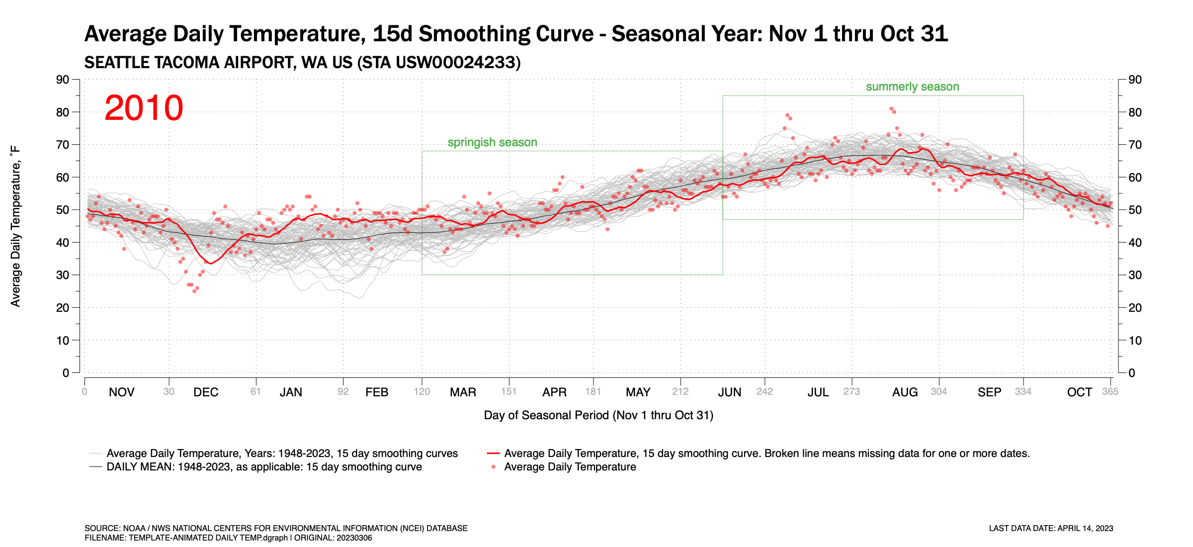
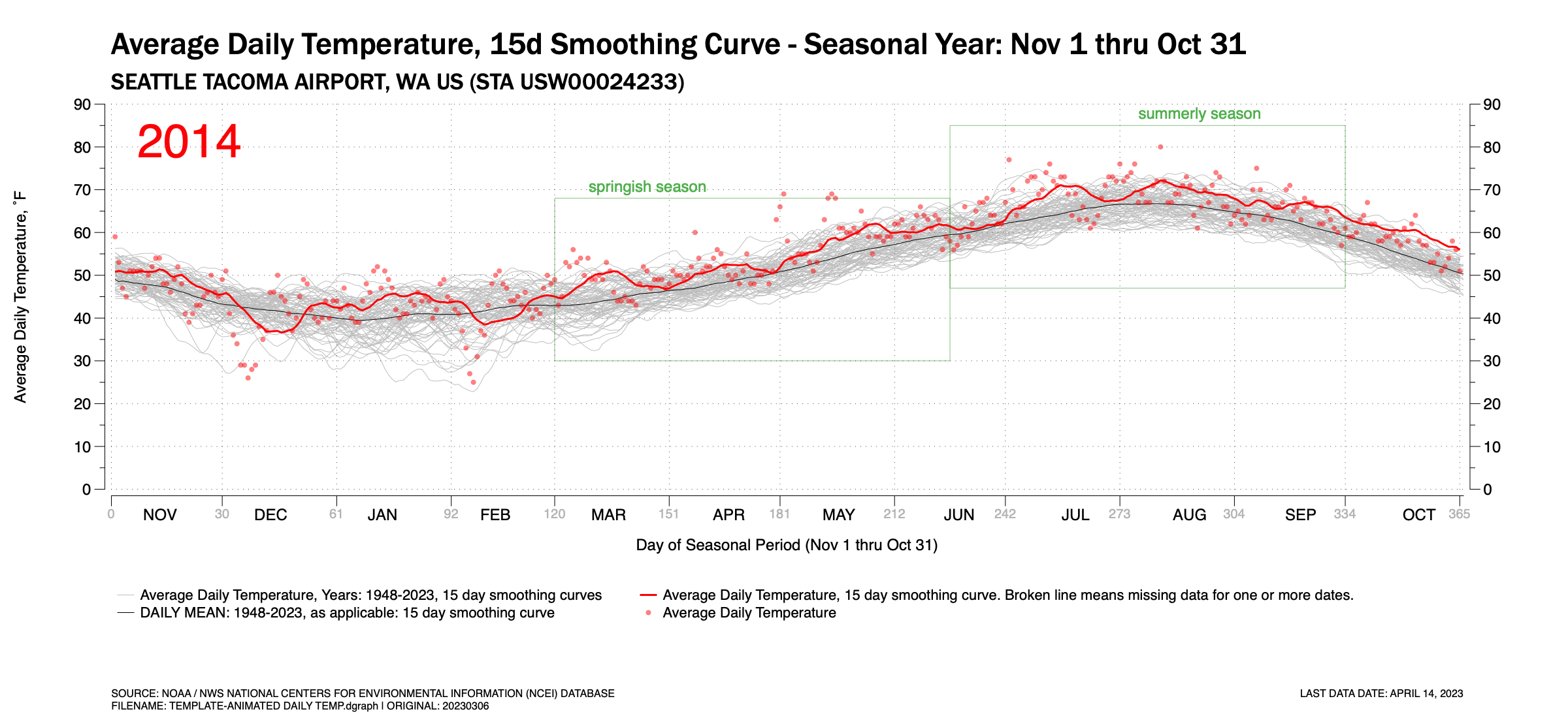
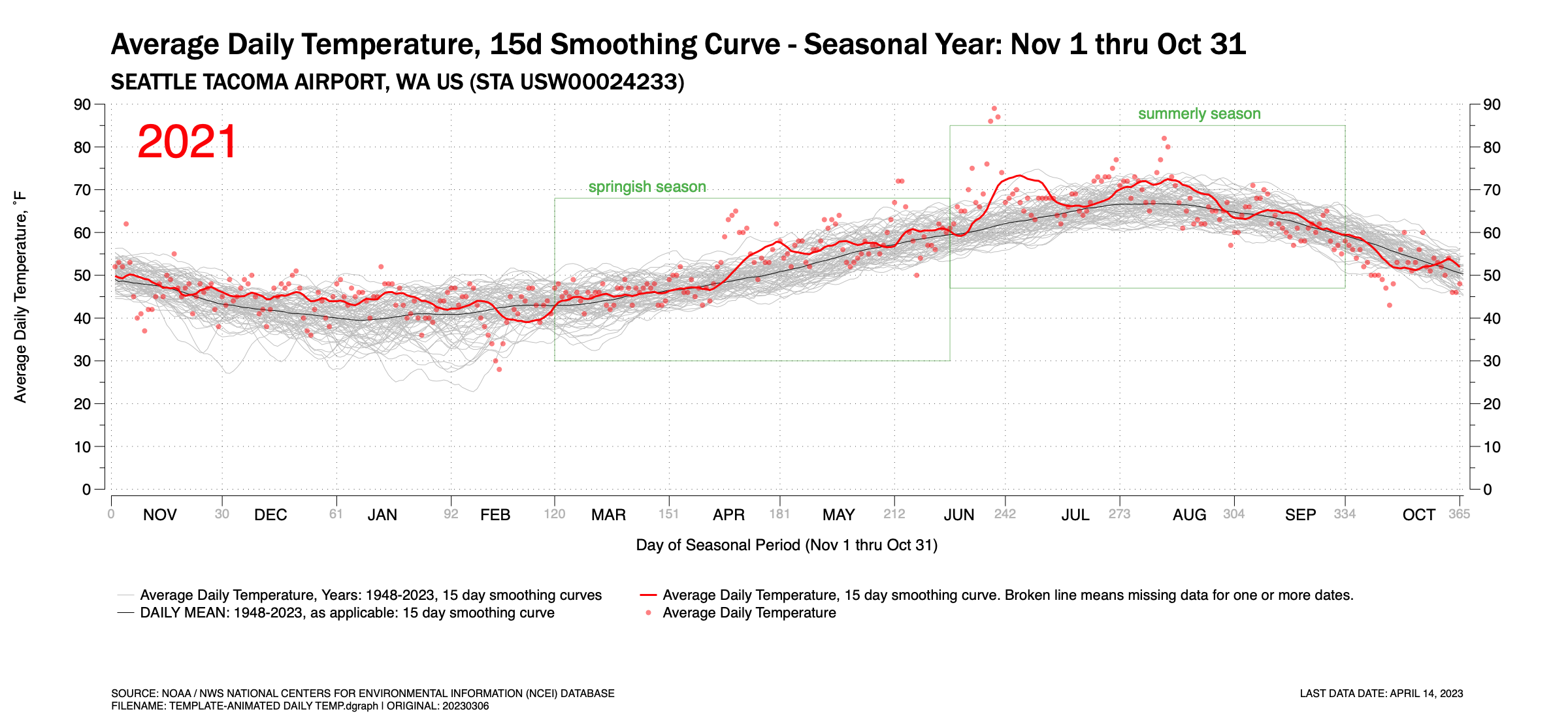
  • Part 2 explores the Average Daily Temperature by day of the seasonal year for the entire period.


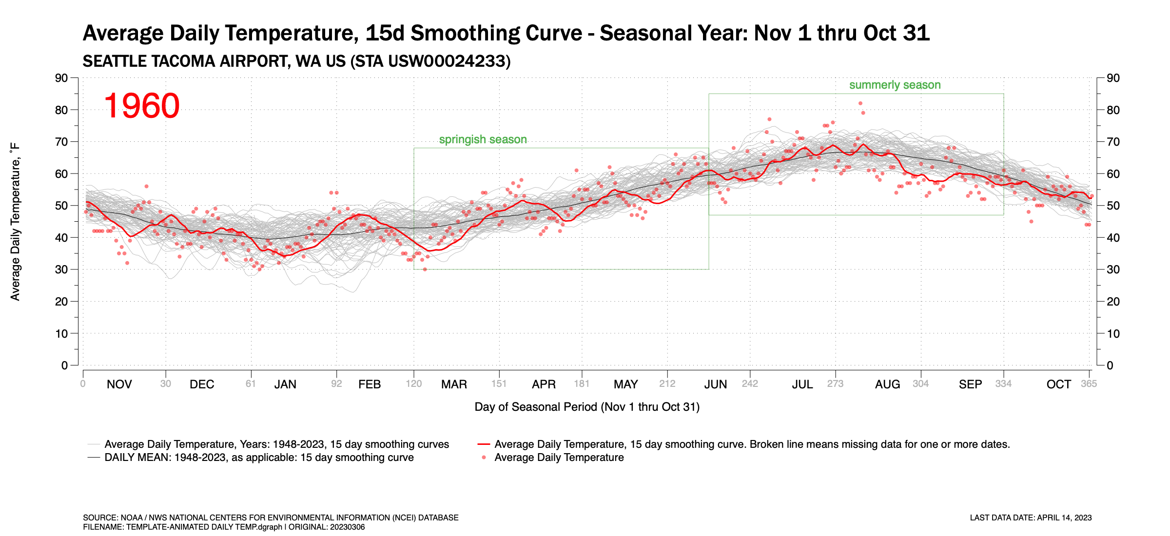
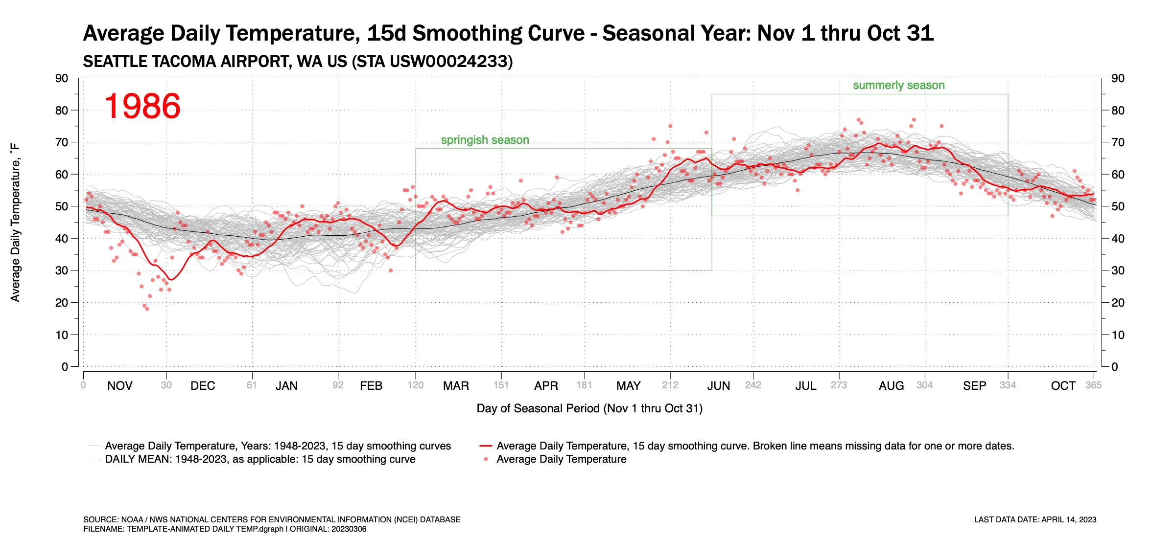
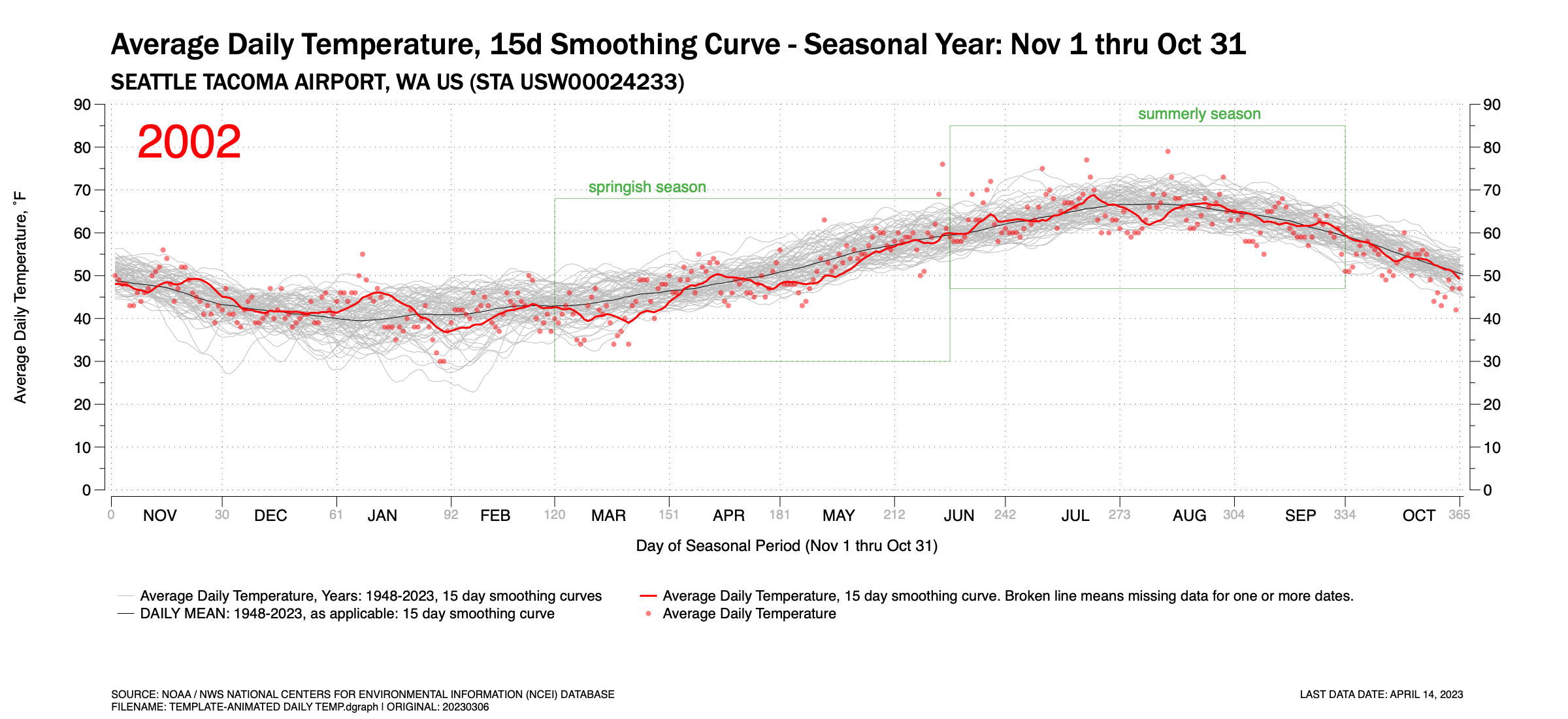
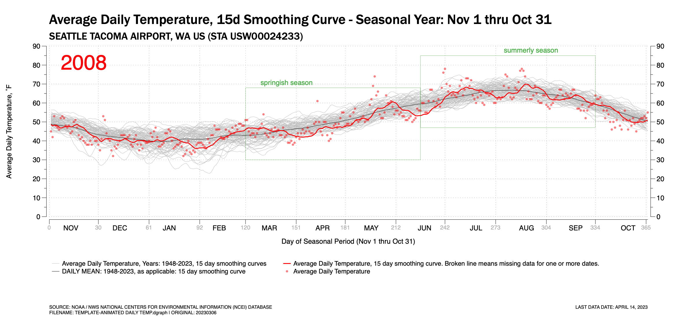
Figure 1 is an animated GIF which pages through the years 1948 through 2023 (to-date) and shows the Average Daily Temperature (ADT) recorded at Seattle Tacoma International Airport. In the background, three basic time-series traces exist: (a) light gray traces of 15-day running averages of the ADT for each year; (b) a red trace showing the  15-day running average of the ADT for the highlighted year; and (c) a dark hairline curve of the 15-day running average for the mean of all years. Individually recorded daily ADTs are show as red points.


The animation highlights the wide year-to-year variability in the ADT as the red highlighted year trace fluctuates across the broader gray traces for each year. Some temporary trends exist though you need to look at them quickly. In the early-mid 1950s, the ADT traces are often in the low half of the temperature band. In the 2010s, the opposite is true. Still, even with this, year-to-year variance fluctuates commonly across the gray temperature traces.


Each highlighted year’s chart is shown in Figure 2. Scroll down to compare. It is easier to compare still images more accurately and studiously. The animation simply shows the wide year-to-year variance.


Figure 1. An animated GIF showing the daily Average Temperature at Seattle-Tacoma International Airport for the years 1948 thru April 2023. Also shown is the 15-day running average and the mean daily temperature for all year, also plotted as a 15-day running average.


Figure 2. Time-Series Plots by Year

Click any chart to enlarge. Hint: Once an annual year shows up, you my be able to navigate using your keyboard’s left and right arrow keys

Seattle's (relatively) cool winter, Part 1...

Updated on April 6, 2023


I first published this blog post on March 18. The day before,  it warmed to the 60’s for the first time since October in and around Seattle. This felt very nice to my cold bones. It has been a relatively cool winter this year if you look at the December – February traditional winter period. January was relatively mild, warm, and dry for a winter period in Seattle. But the traditional meteorological winter was bookended by a coolish December and February. Extend the bookends of the period to November and March (to-date), four of the past five months have been cooler than normal.

My charts only contained data through March 15 when I first published the post on March 18. Now, a week into April, I have data through the end of March. The updated figures below reflect this.

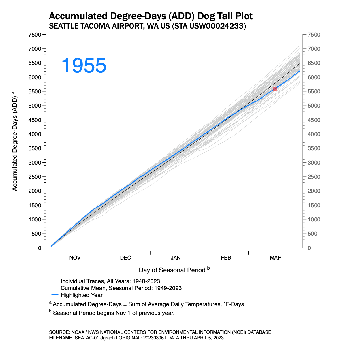
I’ve posted several charts below. Figure 1 is an animation. The chart is a series of traces which track the cumulative average daily temperature recorded at Seattle Tacoma International Airport (KSEA) for the seasonal period of November 1 through March 31 for the years 1949 through 2023.

NOTE: The animation is an animated GIF file programmed to loop through twice. Each loop takes roughly 25 seconds. Refresh the browser window (command+R) to restart the animation.

Figure 1. Accumulated daily average temperature traces by seasonal year, 1949-2023, at Seattle Tacoma International Airport.

A few notes about Figure 1 follow:

  1. I’ve chosen a “made-up” metric. I don’t know if this is used by the National Weather Service, meteorologists, or climatologists with any regularity. I call my metric or index the Accumulated Degree-Day (ADD). It simply takes the average daily temperature recorded at KSEA and adds it to the previous days. It is similar to Heating Degree-Days and Cooling Degree-Days which are commonly summed over a period of time but my ADD does not use a threshold temperature of 65˚F to compare against. But it does give one an idea of how cool or warm the seasonal period has been in comparison to similar periods in other years at a common location.  I suppose it’s units would be ˚F-Days.

  2. The gray traces in the background display each year from 1949-2023 for an aggregate comparison.

  3. A blue trace is highlighted for each individual year as the animation is played.

  4. Since each seasonal period plotted crosses two calendar years, I’ve chosen the latter of the two calendar years to identify each individual trace. So, the trace for the November 2022 – March 2023 period is identified as ‘2023.’

  5. The highlighted blue traces extend to March 31 for each year.

  6. An average ADD trace for all years has been added to the chart for comparison. The ADD trace is shown as a black  hairline. For the total November–March season period, the total average ADD value is 6482 ˚F-Days.

  7. Some data went uncollected by the National Weather Service on March 16-17, 2023 at Seattle Tacoma International Airport which made it difficult to calculate a daily Average Daily Temperature for these dates. The missing data is explained in the chart and the days impacted are shown in a red block on the chart.

  8. Finally, I name the animation a dog tail chart because when played back, especially at higher frame rates, these types of charts look a little like a wagging dog tail. 


So why an animation? Animations display motion, and motion display movement over time and, possibly, patterns. You may want to ask yourself; year-to-year is there any rhythm, pattern or trending that becomes obvious that might be difficult to discern when comparing a series of still images or charts. This is especially true when comparing 74 still images if each chart was published separately (and they are further below).

 And there does appear to be some patterns at the distal ends of this period we’re investigating. In the late 40’s and through the mid-1950’s there are a series of coldish winter seasons(7 of 9 between 1949-1957). This is well documented in old photographs of heavy snows in Seattle during this period. And one could argue that the 2010’s have a pattern of warmer than normal winters (6 of 8 between 2014 through 2021). But mostly, this animation shows the high level of variance fluctuating between cooler-normal-warmer winter cycles. The late 2010’s may have shown warmer periods, but this season is quite cooler. And there were warmer winter seasons in the 1950s.

*****

The individual annual temperature traces which make up the animation are shown below. The are shown in order of the earliest year (1949) to the most current (2023). Click on any individual image below to see more detail and to compare.

NYC's Central Park in Snow...

I’ve never been to New York City though I’ve always wanted to visit and even live there. I remember when I told a colleague I worked with in the Seattle area in the mid 90s and who grew up there, he said 

“Dave, it’d eat you alive.”

 I replied, what do you mean? I’ve been around.

 “You haven’t been to New York. It eats up people like you.”

 I protested, People say this all the time. The whole city’s made up of people from other places.

 “Trust me Dave. It’d eat you alive.” End of conversation. He moved on to another task. I laughed.

 …

Anyway, it is probably too late for me to ever live there, but maybe one day I’ll visit New York. And as a daily reader of the New York Times, I sometimes come across a local story which gets me wistful about visiting or living there sometime. And whenever I do that, I think back to that brief 30 second conversation I had underneath a giant 747 being tested prior to rolling out to the flightline for further finishing work.

 And that happened tonight when I came across a story that NYC might get its first meaningful snowfall of 2023, on nearly the last day of February. I’ve always loved photographs of New York in winter. The old black and white ones, but also the color ones – especially the color ones from the late Saul Leiter. It’s hard to imagine New York getting through a winter with little to no snow. But what do I know?

 I decided to look at how much NYC sees in a typical winter. So, I went to the National Oceanic and Atmospheric Administration’s National Centers for Environmental Information (NCEI) data portal to see where data of records were collected for New York City. Sure enough one of those locations was in Central Park with records going back to January 1, 1869. I downloaded the temperature and precipitation data for this location just for grins and looked.

  And it appears, New York City gets quite a bit of snow in Central Park certainly when compared to the city I live in, Seattle.  It looks like on average about 26 inches over the course of a typical winter falls in Central Park, though that varies widely.

 I put together several charts to see if any patterns or trends over time could be detected. Frankly, I don’t see many from this broad (and quick) overview. In fact, I was surprised how uniform the data looked whether years were grouped across decades or individual snow events were plotted across time.

 You can see what I found with this very cursory look tonight in the following five (5) figures. Click on any chart to expand.

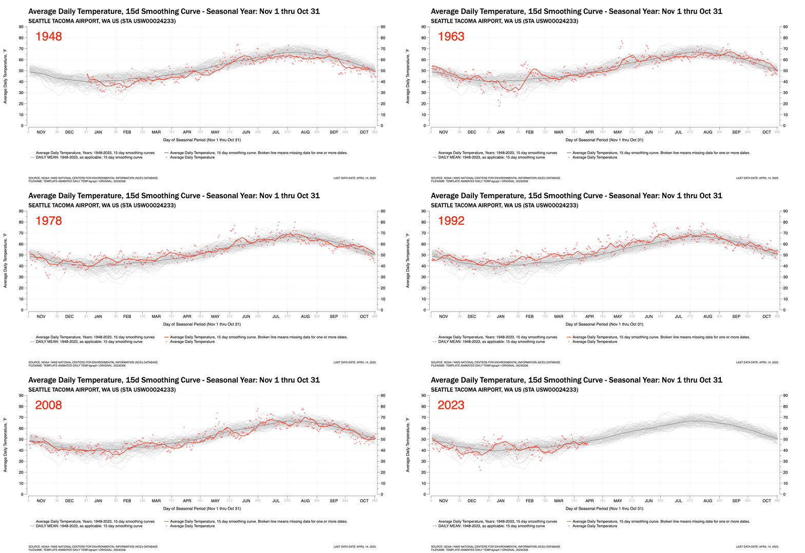
Figure 1. Accumulated snowfall in Central Park. Group in 20 year bins or bars. Note that records only began in 1869. The first bar only includes data for 12 years. The most recent 20-year grouping began only three years ago. Therefore the last bar is quite small on this account.

Click on to expand.

Figure 2. Individual snow events grouped by years (e.g. not individual event dates).

Click on to expand.

Figure 3. Individual snow events grouped plotted on event dates.

Click on to expand.

Figure 4. Individual snow events from 2000-2023 and grouped by years (e.g. not individual event dates).

Click on to expand.

Figure 5. Individual snow events from 2001-2023 and plotted on event dates.

Click on to expand.

DATA SOURCE: NOAA NWS NCEI DAT PORTAL, https://www.ncdc.noaa.gov/cdo-web/, accessed 27 Feb 2023. Station Name: Central Park NYC.

on balance...

The Pacific Northwest experienced an extraordinary heat wave last summer. The heart of the heat wave lasted three days; however the days leading up to and trailing those three core days were also very warm. The average daily temperatures at Seattle-Tacoma International Airport (KSEA) for June 26-28, 2021 exceeded normal daily temperatures by 22˚F, 25˚F and 23˚F respectively for those three hottest days. The actual daily maximum temperatures for this period were 102˚F, 104˚F and 108˚F. This event was covered prominently in local, national and international news and continued to be for months afterwards.

However, in the Seattle area (just a relatively small area impacted by the heat wave), aside from another relatively hot period towards the end of July, the rest of summer was very pleasant. In fact, by mid-August, mean daily temperatures began to fall short of normal August temperatures. September and October, often pleasant and warm months in the Seattle area, were both cloudier and cooler than normal. And aside from a warmish period in late November 2021 when atmospheric rivers from the tropics swept in warm winds and huge rainfalls causing massive flooding in parts of the Pacific Northwest and British Columbia, the past winter and spring has continued to be rather cool and showery.

It has been 317 days since the heat wave broke. I plotted the average daily temperature departures from 30Y-normal mean daily temperatures at SeaTac (KSEA) for these 317 days. I also included the 317 days prior to the heat wave as well in the plot. Including the 3-day heatwave, a total of 637 days are plotted in Figure 1.

Click to enlarge.

Figure 1. Daily departure from normal temperature trends, August 13, 2020 through May 11, 2022.


The temperature trends in Figure 1 appear to show a certain seesaw symmetry around the brief heat wave. The linear fit curve (for just the shown data range) crosses the X-axis about a month after the heat wave broke. The pre-heatwave period had 183 warmer-than-normal days at an average of about 4.8˚F warmer per day. The post-heatwave period had 183 cooler-than-normal days. at an average of roughly 4.3˚F cooler per day. One key difference is that the pre-heatwave period had almost twice the number of neutral days than the post-heatwave period.

I suspect this symmetry is likely more coincidental than anything else and likely had little to do with the large heat dome that set in place last summer and caused temperatures to peak. It likely has much more to do with the strong La Nina pattern we’ve been in this winter and spring. Atmospheric systems are huge and are likely slow to change. Though 637 days sounds like a lot of data points, it’s less than two years and it’s perfectly normal for warm and cool trends to settle in for long periods. But just looking at the chart and thinking in medical terms, it appears the “fever broke” after the extraordinary heat wave.

The truth is, if you look at the longer record and extend this chart backwards for many years as shown in Figure 2 the cooling trend appears much more moderate. This chart goes back to 2000. And a 365-day smoothing curve of average daily temperature departures shows a much more gradual cooling trend (after an extended warming trend reaching back to at least early 2017).

Click to enlarge.

Figure 2. Daily temperature trends, Seattle-Tacoma International Airport, 2000-2022.

A dark start to winter...

Updated: December 29, 2021, 6:30 AM PDT

Figure 1 updated with most recent data.
Figure 2 has been updated. Note that the minimal value on the x-axis begins at 320 MJ/sq.meter. Figure 3 has been updated. Note that the minimal value on the y-axis begins at 300 MJ/sq.meter. Figure 4 has been added to show the daily temperature departure for 2021 to date.
Figure 5 has been added to show the daily temperature departures since 2000 at SeaTac airport.


If it seems like it has been pretty dark and rainy this autumn and early winter in Seattle you would be right. I’ve already posted about the high level of precipitation we’ve seen in Seattle and the extended Western Washington area since the start of the 2021-22 water year on October 1. The areas surrounding Bellingham and Vancouver B.C. have been especially hit hard with rain.

But it has seemed very dark in recent months as well, and by dark, I mean low levels of light. Of course all this rain comes in leaden skies. And looking at solar radiation data collected near Husky Stadium and Union Bay (47.66, 122.29) in Seattle confirms this has been the darkest start to winter in the past ten. Washington State University operates a solar collection station in this area and exposes the processed data to the public on their web site. A link to this data is listed at the bottom of this page.

Figure 1 shows the cumulative daily totals of solar radiation (MJ/sq.meter) from October 1 through December 31 for 2013 through the present year. At this writing we are only partly through December this year. But it is clear that this year has been quite dark compared to the other years. Lower traces indicate lower levels of solar energy measured. This year’s trend line is the heavy line. The Seattle area began with a normal October, but around mid-month the rate of cumulative solar energy slowed considerably.

I choose a start date of October 1 since this is the traditional start date of the Northwest water year, the time of year when storms begin to blow off the Pacific with increasing frequency. This date provides a good start or “zero point” for the start of the wet season.

Figure 1. Solar radiation measured at Seattle’s Union Bay data collection site.


Figure 2 was added on December 15. This figure is a dot plot showing the total cumulative solar radiation received at WSU’s Solar Station in Seattle. The dot plot is sorted by total solar daily accumulation for the stated period.

This year’s accumulation of sunlight since the start of October is marked by the black dot in the lower left corner. It is substantially lower than the sunnier years at winter’s start. It is substantially lower than the median value for all years shown. The median value is shown by the dash vertical line.

Looking at the years’ positions on the y-axis, there does not appear to be any pattern to the order for the very limited number of years for which data exists.

Figure 2. Dot plot showing cumulative solar radiation sorted by year.


Figure 3 essentially shows the same data as Figure 2. In this bar chart, the years are in order along the X-axis (horizontal). It’s a little easier for the mind to see the lack of any pattern by time in this small sample size – we are more often used to seeing date-format data along the horizontal axis, increasing in time from left-to-right. It’s also clear to see how low sun levels have been this Oct-Dec period compared to recent years. All years show data through the date in the title.

Figure 3. Cumulative Solar Radiation, Oct 1 through December, sorted by years, 2012-21.


In addition to lower solar radiation levels in Seattle since roughly mid-October, it has been a relatively cool autumn and start to winter. September had mare days that were cooler than normal than days warmer than normal. Same for October. November was pretty mild with a series of atmospheric rivers coming in from the tropics. Those brought warmish, moist air with them. And plenty of flooding in parts of the Pacific Northwest and southern British Columbia. December has been relatively colder than most recent Decembers. This can be seen in the large number of days where average daily temperatures have been below 30Y climatic normals.

Figure 4 shows the daily temperature departures for 2021 up through the most recent date.

Figure 4. Daily Average Temperature: Departure from 30Y normals. Click to enlarge.

Figure 5 shows similar data as Figure 4, daily average temperature departures from 30-year normals going back to January 1, 2000. It appears in recent years, the trend is back towards the climatic normals of the past 30 years after a warming period for several years in the mid-2020s.

The 30Y normal daily average temperature reference values for all years except 2021 are based on the years 1981-2010. In 2021, the comparison is against the normal daily temperature range from 1991-2020. It’s possible that the 1991-2020 30Y normals cycles have increased from the previous 1981-2010 30Y cycle and this year’s lower trend is simply reflecting that change - departures may be comparing against a high reference line..

This data is for the National Weather Services’s Seattle-Tacoma International Airport site.

Figure 5. Daily normal temperature departures for SeaTac airport from 2000 to present. Click to enlarge.


SOURCE DATA
Washington State University AgWeatherNet: http://weather.wsu.edu
NOAA/NWS Climate Data Seattle/Tacoma https://www.weather.gov/wrh/climate?wfo=sew
FULL DISCLOSURE
I am not a meteorologist, climate scientist, data scientist, geologist nor hydrologist. I am simply a (retired) engineer who has some familiarity with numbers, basic statistics and probability statistics who enjoys looking at readily available public data and trying to make sense of things. I enjoy building data visualizations from data I find much like others enjoy working daily crosswords or sudoku puzzles. Local weather, climate and hydrology science are complex subjects. Take what you read and find here with this in context.
 

Rearview Mirror: November 2021

The November 2021 Temperature Departure chart is shown in Figure 1.

In general we’ve had a somewhat cooler than normal autumn, but November was slightly warmer than normal, with a monthly temperature average of 47.9˚F, about 1.4F above normal. Several strong atmospheric storms hitting the Puget Sound region from the tropics to the southwest passed through the city mid-month and towards the end. These storms brought warm, tropic air with them with plenty of moisture. These multi-day temperature spikes can be seen in Figure 1.

Figure 1. Daily temperature departs from 30Y climatic normals through November 30.

Click image to enlarge.

Normally, I’d add a chart showing new monthly precipitation totals, but I’ve reported these in several previous blog posts over the past few days. There’s no sense repeating that information here. Click to Prev button at the bottom of this post to navigate to those posts if you’re interested.


DATA SOURCE
NOAA / National Weather Service Local Climate: https://www.weather.gov/wrh/climate?wfo=sew

On Seattle-Tacoma precipitation traces, Part 1...

This post will display a history of water-year cumulative precipitation traces from Seattle-Tacoma International Airport. A water-year defined here crosses parts of two calendar years and runs from October 1 of year 1 to September 30 of year 2. For instance, the water year 1972-73 runs from October 1, 1972 to September 30, 1973.

The reasons for using water years is simple. The Puget Sound area can be thought of at a higher level of having two basic seasons: a wet season running from October through March when most of our annual precipitation falls, and a dry season which runs from April through September.

Figure 1 is the baseline chart and shows cumulative precipitation traces at Seattle-Tacoma International Airport from 1948-49 through the start of the 2021-22 water years. The data comes from the National Oceanic and Atmospheric Administration (NOAA) and the National Weather Service (NWS). These data extracts normally list daily precipitation totals. I’ve summed these values up for each water year.

Figure 1 also shows some other graphic elements. In the lower left corner, a blue box appears highlighting the first two months of the water year. The reasons for this box is simple. We just completed this two month period for the 2021-22 water year. It was a very wet period in Seattle and the Pacific Northwest in general. I placed this box on the chart to allow for easy comparisons of this year’s heavy rains with other years’. As you will see later, this year’s start to the water year was one of the wettest since the late 1940s, but not the wettest.

Two other key elements added to the baseline chart include a 30Y climatic normal reference line for two climate periods. These periods are the 1981-2010 climate normals for precipitation at SeaTac and the 1991-2020 climate normals. These are standard 30 year daily averages published by NOAA/NWS. As you can see, the more recent 30 year normals show a higher level of daily precipitation than the 1981-2010 period, adding up to a little more than 2 inches additional rain per year at SeaTac.

One final observation is that precipitation rates vary widely within each annual trace and between the final annual totals of all traces. The wettest years had roughly 51-52 inches of rain over the course of 12 months, the driest years had less than 25 inches over a 12 month period.

Figure 1. Precipitation traces for each water year from 1948-49 through 2021-22 (to the current date).


I only have two full water-year traces from the 1940s. These are shown in Figure 2. Interestingly, both years began the first two months with similar trace patterns. After about mid-December, each trace line diverges for the remainder of the year, one towards the high side of annual precipitation totals, the other towards the low end. At a glance, and without performing the statistical calculation, it appears as if the final year-end totals span the first or second standard deviations of all year-end precipitation totals.

Figure 2. Cumulative precipitation traces for available SeaTac data in the 1940s.


The 1950 traces in Figure 3 show that the start of the wet seasons varied widely during that decade and that, in general, it was a decade when annual precipitation totals hewed towards current climate normals or were generally higher in precipitation.

Figure 3. Cumulative precipitation traces for available SeaTac data in the 1950s. Tracks in the 1950s trend towards years with greater precipitation.


Figure 4 shows the 1960s traces were distributed about evenly above and below current climate normals and tend to not have extraordinarily wet or dry annual totals.

Figure 4. Cumulative precipitation traces for available SeaTac data in the 1960s. Precipitation tracks in the 1960s hover more closely to 30Y climate tracks about evenly above and below these normals.


Figure 5 shows the 1970s traces. It appears most years in the 1970s began relatively dry. From December on, the annual totals varied widely. This might be the decade with the widest and most uniform spread between very wet and very dry years.

Figure 7. Cumulative precipitation traces for available SeaTac data in the 1970s. Half the 1970’s traces hover close to the climate normals. The remaining traces are biased towards both extremes: wet years or dry years.


Most annual traces in the 1980s hewed close to current climatic normals, though biased on the dry side of those normal. Figure 6 shows a few years were substantially drier by year’s end.

Figure 8. Cumulative precipitation traces for available SeaTac data in the 1980s. The 1980’s traces tend to be biased towards drier than climatic normal years. The also tended to start the years tightly around climatic normals.


The precipitation traces for the 1990s, illustrated in Figure 7, appear to be evenly distributed around the current climatic norms much like the 1960s traces. However, the 1990s traces are dispersed more widely, reaching towards the wettest and driest annual limits for all of the traces. Collectively, the 1960s and 1990s traces in the early part of each year exhibit pretty similar patterns, hewing close to current climatic normals except for one particularly dry autumn in each subset.

Figure 7. Most years began with fairly normal precipitation levels except for perhaps two. By years’ end, the traces were evenly, if broadly, distributed around current climatic normals. This decade saw the most varied ditribution of precipitation totals at the end of the year.


Figure 8 shows the traces for the 2000s. The year end precipitation totals tend not to trend towards extremes and are maybe slightly biased towards drier years. But the start of the wet season (October-November) varied widely for this period. Some of the wettest starts to winter began here and even a drier one as well. Many other decade charts showed must tighter distributions around the current climatic normal lines.

Figure 8. Cumulative precipitation traces for available SeaTac data in the 2000s. Traces appear to show wide autumn variations then trending towards an even distribution around climatic norms at years end.


The 2010s year-end precipitation totals trended towards wetter years. These traces are illustrated in Figure 9. This decade, along with four very wet years in the 1990s might explain why climatic normal curves jumped for the 1991-2020 period. The starts of the water-years in the 2010s also trended towards wetter Octobers and Novembers in most years. The 2010s also hosted some very long, dry summer periods.

Figure 9. Cumulative precipitation traces for available SeaTac data in the 2010s. Trends show wide variation in the autumn months and a bias towards wetter year-end totals.


The 2020s are too new to host many precipitation traces. In fact, we’ve only completed one year of this decade and only started a second water-year trace. In Figure 10, the single, complete year hewed very closely towards climatic normals after a wet late winter and early spring. This was followed by a very long and dry late spring and summer period.

The start of its second year has been very wet.

Figure 10. Cumulative precipitation traces for available SeaTac data in the 2020s. The 2020-21 year followed current climatic normals closely. The current year has begun very wet.


Conclusions and Notes

Looking at the traces, I’m not really sure I’m seeing any convincing trending decade-to-decade. The only long-term trending I’m seeing is between the climatic normal lines where wetter late winters and early springs seem to be trending. But these two lines are drawn from only two sets of averaged daily data. I would be more convinced if other 30-year climatic normal periods were plotted here, say for the 1951-80, 1961-90 and 1971-2000 periods. I may do so for Part 2 of this blog entry.

Sure, the 2010s appear to be quite wet. But that decade was preceded by several decades of precipitation traces distributed pretty evenly around the climatic normal curves. And the 1970s and 80s trended towards the drier side of the distributions. They, in turn, were preceded by a pretty normal series of plots in the 1960s and, again, wetter trending in the 1950s. Who knows what’s in store for this decade. It’s way too soon to tell.

And this second point brings up an important third one: the arbitrary definition of a decadal dataset. I used the common calendar dates to group my datasets and plots, begin each set of plots with a year ending in a zero and enclosing the dataset with a trace from a year ending in a nine. But I could have just as easily chosen decadal sets such as 1974-83; 1984-93; 1994-03; etc. Who knows what trends we might detect then?

***

I think I’ll plot a Part 2 post to this topic. It will take some time due to the need to post-process the data. I have data preceding the 1950s going all the way back to the 1890s for the Seattle area. However, this data is typically from other locations, including the Portage Bay area in North Seattle and Boeing Field in South Seattle. These areas are 10-20 miles from Seattle-Tacoma Airport.

I think too, I will plot climatic normal curves for other 30-year periods to see if any trending is detected within those longer-term datasets.

That’s all for now.

Pacific Northwest autumn 2021 rains...

Updated: December 1, 8:00 AM PDT

This post has been substantially updated on Wednesday morning, December 1.

  • One chart has been replaced by five (5) charts with further explanations and comparisons.

  • Data has been updated to include precipitation totals through November.

  • Vancouver’s annual precipitation totals have been corrected to state the 1981-2010 30Y average for Vancouver International Airport as 46.8 inches. In the original blog post, it listed the 30Y annual average for Vancouver’s Harbour climate station site. This site has a considerably higher average than the airport.

  • On Figures 2 thru 5 a new reference line has been added for the recently released 1991-2020 climate precipitation normals for Seattle-Tacoma International Airport. As you can see, the most recent 30Y normal reference line show it has been wetter in Seattle in recent decades.

All figures subject to correction and, if required, will be noted.

Click on any chart to expand.


The Pacific Northwest almost always experiences rainy Novembers. This year precipitation rates have been high, if not extraordinary. Heavy flooding occurred in northwest Washington and southern British Columbia in mid-month. Since then, rains have levelled off a little but are accumulating nonetheless. This weekend we are expecting more rain in Seattle. Bellingham and Vancouver will likely see even more.

So how does this start to the rainy season compare to others? The charts below shows several comparisons:

Figure 1 sets the table for this data and subsequent charts and shows the cumulative precipitation traces at Seattle-Tacoma International Airport (SeaTac) for the water years 2002-03 through 2021-22 (to-date). Water years are calendar constructs which help visualize the wet season precipitation totals vs. dry season in the Pacific Northwest. Typically a water year begins on October 1 of a given year and runs through September 30 of the following year. Looking at cumulative precipitation traces in this time frame usually show distinct wet / dry season patterns.

Figure 1 also highlights the 2006-07 water year. Seattle experienced an extraordinary level of precipitation in November 2006, the most of any traces for SeaTac in this set of data. The blue box in this and subsequent charts highlights for comparison the level of precipitation versus the first 61 days of the 2006-07 water year and corresponds to the months of October and November.

Figure 1. Record-setting Oct-Nov at Seattle-Tacoma International Airport, 2006.


Figure 2 highlights the amount of precipitation SeaTac has received so far this water year. As mentioned in the updates, the 1991-2020 climate normal reference trace has been added to this and subsequent charts.

Figure 2. Seattle-Tacoma International Airport cumulative precipitation for Oct-Nov, 2021.


Figure 3 shows the accumulated precipitation trace (red) for Bellingham International Airport. Bellingham is approximately 90 miles north of Seattle and was hard hit by the mid-November flood.

Figure 3. Oct-Nov accumulated precipitation for Bellingham International Airport compared to SeaTac totals, 2021.


Figure 4 shows the accumulated precipitation (blue) trace for the Vancouver International Airport weather station. Vancouver is approximately 50 miles north of Bellingham. In the last few days of November, Bellingham has seen more rain than at Vancouver’s airport climate station.

Figure 4. Vancouver International Airport and Bellingham International Airport cumulative precipitation totals for Oct-Nov, 2021.


Figure 5 compares the accumulated precipitation at Vancouver’s airport in it southwest corner to its Harbour climate station located near Stanley Park. This station is near the core of downtown Vancouver. The station at Vancouver’s Harbour has seen far more rain this water year than at the airport.

Figure 5. Vancouver International Airport and Vancouver Harbour precipitation totals for Oct-Nov, 2021.


Preliminary observations:

  • Seattle and Bellingham have had similar precipitation totals through this period though they arrived at this point in slightly different manners. Over the past 48-96 hours Bellingham has received substantially more rain than Seattle.

  • The precipitation totals at Vancouver International Airport for October-November are similar to Bellingham’s.

  • The precipitation totals witnessed at Vancouver’s Harbour climate station far exceed totals in the Washington cities and at Vancouver’s airport. I don’t know if this level of disparity is typical. However, with regards to the comparison with Washington cities, Vancouver typically sees approximately 46.8 inches of rain per year; Seattle sees – with the new 30 year climate normals – about 39.3 inches of precipitation per year.


Sources:

[1] NOAA / NWS Climate\Observed Weather: https://www.weather.gov/wrh/climate?wfo=sew for SeaTac and Bellingham data.

[2] Canadian Government Historical Climate Data: https://climate.weather.gc.ca/historical_data/search_historic_data_e.html


ABOUT THIS BLOG / FULL DISCLOSURE

I am not a meteorologist, climate scientist, data scientist, geologist nor hydrologist. I am simply a (retired) engineer who has some familiarity with numbers, basic statistics and probability statistics who enjoys looking at readily available public data and trying to make sense of things. I enjoy building data visualizations from data I find much like others enjoy working daily crosswords or sudoku puzzles. Local weather, climate and hydrology science are complex subjects. Take what you read and find here with this in context.

An especially dark and dreary winter...

This has been an extraordinary dark and dreary winter in Seattle. A dotplot of the cumulative daily Sky Cover scores for SeaTac International Airport shows the period between December 1, 2019 though January 29, 2020 far exceeds the scores for similar periods back to 2006-07.


Another way to view the darkness this winter is to look at the average daily solar radiation, measured in MJ/m^2. This data is available from Washington State University.

Extracting data from their ‘Seattle’ location – which I beleive is on the campus of the University of Washington, but subject to correction – you can see that the average daily solar radiation for this winter (December 2019-January 2020) is the lowest value for the past nine years, years in which data is available for this location.


Click to enlarge…


Finally, look at the rain pattern over this same December-January period this water year (a water year calendar runs from Oct 1 thru Sep 30 due to rain patterns in the Pacific Northwest). The line chart below shows that as of January 29, SeaTac International Airport has accumulated almost the exact normal amount of precipitation to be expected based on the 30-year average for this location (established from records for the 1981-2010 period).

But this year, the first 2-½ months of the water year were relatively dry. It wasn’t until about mid-December when the rains began catching up to the 30-year average. It’s taken a lot of steady dark, water-heavy clouds to drop this amount of rain in a relatively short period. This information supports the high level of daily cloudiness and low level of solar radiation shown in the first two charts.

Click to enlarge.